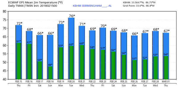
SPRING PREVIEW: The overall upper air pattern across North America won’t be changing anytime soon. A strong upper ridge over the Gulf of Mexico is the main player for us, meaning mostly cloudy days, mild temperatures, and some risk of showers for the foreseeable future. Any showers today across Alabama should be pretty isolated, and we might see some breaks in the cloud cover this afternoon, pushing temperatures into the 70s. The record high for Birmingham for February 15 is 80 set in 1979… we won’t get there, but where the sun breaks out some places could see mid to upper 70s.
TOMORROW AND THE WEEKEND: A surface front will approach from the north, and become stationary over southern Tennessee. This means mostly cloudy weather will continue on all three days with highs in the 60s. Showers are a good possibility tomorrow afternoon, tomorrow night, and Saturday, with the highest coverage over the Tennessee Valley region of far North Alabama. Showers will be more scattered in nature to the south for places like Tuscaloosa, Birmingham, Anniston, and Gadsden… and we expect few showers over the southern half of the state.
No worries with severe thunderstorms or flooding, and Sunday will trend drier with only widely scattered showers.
NEXT WEEK: The ridge actually strengthens a bit; it sure looks like we will see highs in the 70s much of the week for a nice preview of spring. In fact, the 00Z GFS is printing a high of 80 for Birmingham on Tuesday. If by chance that verifies, it will be a new record (the current record for February 20 is 78 set in 1986. Each day the sky will be mostly cloudy, and each day there will be some risk of showers. It will be very hard to find a bight sunny day in this kind of setup.
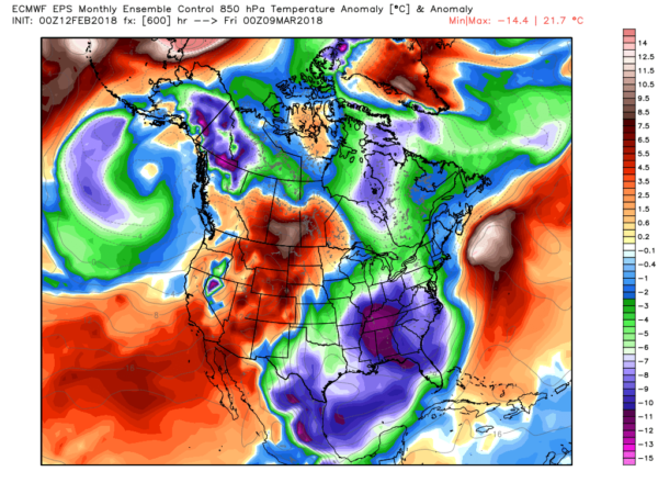
IS WINTER OVER? No. We always have cold snaps in March and April, and the European ensemble hints of one in early March…
See the Weather Xtreme video for maps, graphics, and more details.
BEACH FORECAST: Click here to see the AlabamaWx Beach Forecast Center page.
WEATHER BRAINS: Don’t forget you can listen to our weekly 90 minute netcast anytime on the web, or on iTunes. This is the show all about weather featuring many familiar voices, including our meteorologists here at ABC 33/40.
CONNECT: You can find me on all of the major social networks…
Facebook
Twitter
Google Plus
Instagram
Pinterest
Snapchat: spannwx
I have a weather program this morning at Boaz Elementary School… be looking for the next Weather Xtreme video here by 4:00 this afternoon. Enjoy the day!
from The Alabama Weather Blog https://www.alabamawx.com/?p=152905
No comments:
Post a Comment