MORE RECORDS: Here are some 3:00 p.m. temperatures across the great state of Alabama…
Demopolis 84
Tuscaloosa 83 (new record; old record was 80 set in 1980)
Montgomery 82 (ties the record for February 22 set in 1897)
Auburn 82
Gadsden 81
Pell City 81
Prattville 81
Birmingham 79 (two degrees shy of the record for February 22, 81 set in 1897)
Anniston 79 (new record; old record was 75 set in 1980)
The radar is fairly quiet; earlier showers and storms over the Tennessee Valley have pretty much dissipated. The upper ridge, responsible for the record warmth, will actually ease closer to Alabama tomorrow, so it will be very warm and mostly dry with only isolated showers. The high tomorrow will be very close to 80 degrees.
WEEKEND STORMS: Saturday will be a warm, breezy day with a high close to 80; a few scattered showers are possible. But, an organized band of rain and storms will move through late Saturday night into at least Sunday morning. SPC maintains the standard “slight risk” of severe storms for areas west of a line from Huntsville to Blount Springs to Northport to Emelle. A “marginal risk” has been defined for Tuscaloosa, Birmingham, Anniston, and Gadsden.
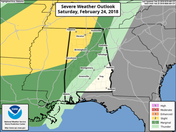
TIMING: Storms should enter Northwest Alabama late Saturday night between 10:00 and 12:00 midnight… then moving slowly to the southeast, reaching places like Birmingham, Tuscaloosa, Anniston, and Gadsden between 3:00 and 6:00 a.m. The main window for stronger storms will come from 10:00 p.m. Saturday through 6:00 a.m. Sunday.
THREATS: The main issue will be strong straight line winds over Northwest Alabama, although an isolated short lived tornado or two can’t be totally ruled out. Storms should slowly weaken as they move deeper into Alabama, and the overall severe weather threat for Birmingham, Tuscaloosa, Anniston, and Gadsden looks relatively low for now with limited instability and the better dynamics pulling away to the north. But, you have to keep a close eye on storms associated with fronts like this in late February.
RAIN: Rain amounts of one to two inches are likely, and we can’t totally rule out some flooding issues with the band of rain and storms slowing down Sunday morning.
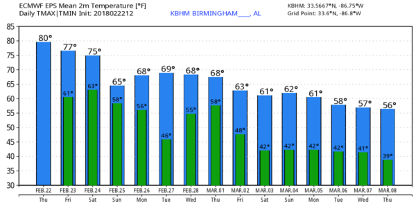
Sunday will be noticeably cooler; some communities north of Birmingham won’t get out of the 50s.
NEXT WEEK: The European global model suggests we will need to keep a chance of rain in the forecast Monday, but drier air will slip in here for one day on Tuesday. Then, more showers are possible Wednesday and Thursday, followed by even cooler air at the end of the week and into the following weekend. See the Weather Xtreme video for maps, graphics, and more details.
BEACH FORECAST: Click here to see the AlabamaWx Beach Forecast Center page.
WEATHER BRAINS: Don’t forget you can listen to our weekly 90 minute netcast anytime on the web, or on iTunes. This is the show all about weather featuring many familiar voices, including our meteorologists here at ABC 33/40.
CONNECT: You can find me on all of the major social networks…
Facebook
Twitter
Google Plus
Instagram
Pinterest
Snapchat: spannwx
Look for the next Weather Xtreme video here by 7:00 a.m. tomorrow…
from The Alabama Weather Blog https://www.alabamawx.com/?p=153250

No comments:
Post a Comment