![GOES-16 “Red” Visible (0.64 µm) and “Clean” Infrared Window (10.35 µm) images [click to play animation | MP4]](https://cimss.ssec.wisc.edu/satellite-blog/images/2020/08/laura_vis-20200825_180125.png)
GOES-16 “Red” Visible (0.64 µm) and “Clean” Infrared Window (10.35 µm) images [click to play animation | MP4]
1-minute
Mesoscale Domain Sector GOES-16
(GOES-East) “Red” Visible (
0.64 µm) and “Clean” Infrared Window (
10.35 µm) images
(above) showed
Laura during the the 12-hour period after it intensified from a Tropical Storm to a Hurricane in the southern Gulf of Mexico at 1215 UTC on 25 August 2020. Numerous convective overshooting tops were observed, some exhibiting cloud-top infrared brightness temperatures as cold as -87ºC.
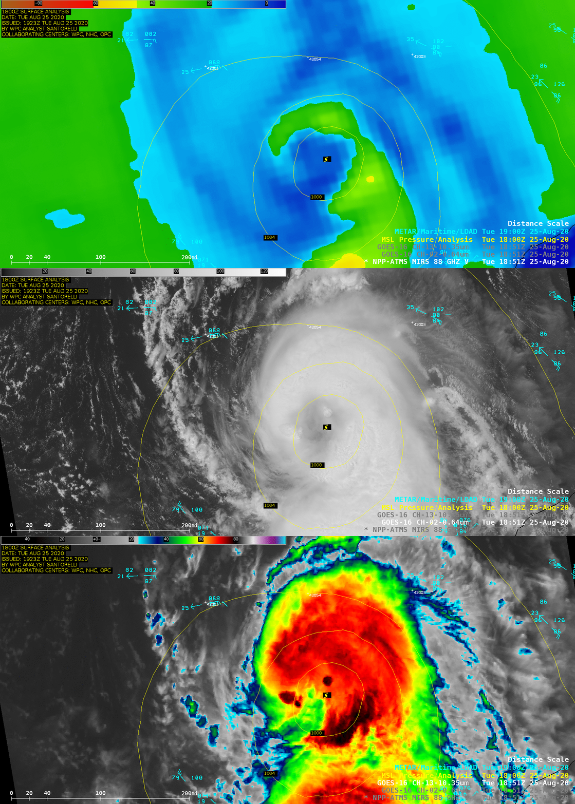
A comparison of NOAA-20 MiRS Microwave (88 GHz), GOES-16 “Red” Visible (0.64 µm) and GOES-16 “Clean” Infrared Window (10.35 µm) images at 1851 UTC (below) revealed a curved convective band wrapping around the eye of Laura.

NOAA-20 MIRS Microwave (88 GHz), GOES-16 “Red” Visible (0.64 µm) and GOES-16 “Clean” Infrared Window (10.35 µm) images at 1851 UTC [click to enlarge]
In a toggle between Infrared Window images from Suomi NPP (11.45 µm) and GOES-16 (10.35 µm) at 1943 UTC
(below), the coldest cloud-top infrared brightness temperature was -91.9ºC in the Suomi NPP image (compared to -87.0ºC on the GOES-16 image). The northwestward
parallax displacement associated with GOES-16 imagery over the southern Gulf of Mexico was also apparent.
![Infrared Window images from Suomi NPP (11.45 µm) and GOES-16 (10.35 µm) images at 1943 UTC [click to enlarge]](https://cimss.ssec.wisc.edu/satellite-blog/images/2020/08/200825_1943utc_suomiNPP_goes16_infrared_Hurricane_Laura_anim.gif)
Infrared Window images from Suomi NPP (11.45 µm) and GOES-16 (10.35 µm) at 1943 UTC [click to enlarge]
from CIMSS Satellite Blog
https://cimss.ssec.wisc.edu/satellite-blog/archives/38092
![GOES-16 “Red” Visible (0.64 µm) and “Clean” Infrared Window (10.35 µm) images [click to play animation | MP4]](https://cimss.ssec.wisc.edu/satellite-blog/images/2020/08/laura_vis-20200825_180125.png)

![Infrared Window images from Suomi NPP (11.45 µm) and GOES-16 (10.35 µm) images at 1943 UTC [click to enlarge]](https://cimss.ssec.wisc.edu/satellite-blog/images/2020/08/200825_1943utc_suomiNPP_goes16_infrared_Hurricane_Laura_anim.gif)
No comments:
Post a Comment