![GOES-17 “Red” Visible (0.64 µm) images [click to play animation | MP4]](https://cimss.ssec.wisc.edu/satellite-blog/images/2020/06/hi_vis-20200701_021117.png)
GOES-17 “Red” Visible (0.64 µm) images [click to play animation | MP4]
GOES-17
(GOES-West) “Red” Visible (
0.64 µm) images
(above) revealed 3 cyclonically-rotating
actinoform clouds that were moving west-southwestward toward the Hawaiian Islands on 30 June 2020 (
surface analyses).
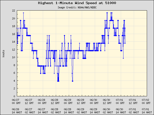
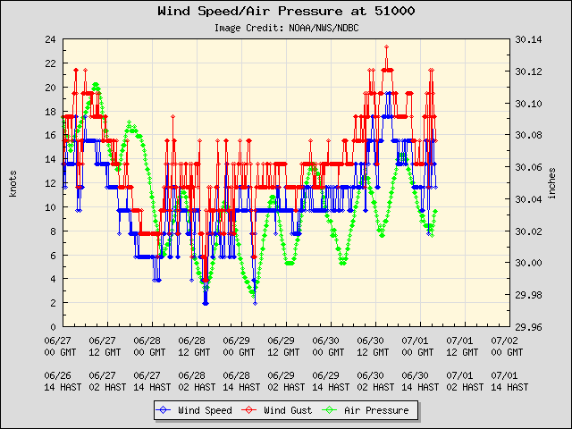
A closer look at the northernmost actinoform feature showed it moving over Buoy 51000 northeast of Hawai’i around 04 UTC on 01 July — there was somewhat of an increase in 1-minute wind speeds and wind gusts as it approached, but no obvious perturbation was seen in the air pressure (it appeared to have arrived during the typical ~12-hourly drop in pressure).
![GOES-17 “Red” Visible (0.64 µm) images [click to play animation | MP4]](https://cimss.ssec.wisc.edu/satellite-blog/images/2020/06/hi_vis_zoom-20200701_021117.png)
GOES-17 “Red” Visible (0.64 µm) images [click to play animation | MP4]
A sequence of 3 hourly (at 0010, 0110 and 0210 UTC) panoramic camera views from Buoy 51000
(below) suggested that there were rain showers reaching the ocean surface beneath one of the actinoform’s radial arms at 0210 UTC (
GOES-17 Visible image).
![Sequence of 3 hourly (at 0010, 0110 and 0210 UTC) panoramic camera views from Buoy 51000 [click to enlarge]](https://cimss.ssec.wisc.edu/satellite-blog/images/2020/06/200630_buoy51000_panoramic_images_anim.gif)
Sequence of 3 hourly panoramic camera views from Buoy 51000, at 0010, 0110 and 0210 UTC [click to enlarge]
True Color RGB and Infrared Window (11.45 µm) images from NOAA-20 and Suomi NPP as visualized using
RealEarth (below) provided a detailed view of 2 of the actinoform clouds. The radial arms that comprised the cloud features remained within the marine boundary layer, so they exhibited fairly warm cloud-top infrared brightness temperatures.
![True Color RGB and Infrared Window (11.45 µm) images from NOAA-20 and Suomi NPP [click to enlarge]](https://cimss.ssec.wisc.edu/satellite-blog/images/2020/06/200630_2307utc_noaa20_2357utc_suomiNPP_viirs_trueColorRGB_infraredWindow_HI_actinoform_anim.gif)
True Color RGB and Infrared Window (11.45 µm) images from NOAA-20 and Suomi NPP [click to enlarge]
Other examples of actinoform clouds have been shown in
May 2019,
March 2008,
March 2007 and
June 1997.
from CIMSS Satellite Blog
https://cimss.ssec.wisc.edu/satellite-blog/archives/37380
![GOES-17 “Red” Visible (0.64 µm) images [click to play animation | MP4]](https://cimss.ssec.wisc.edu/satellite-blog/images/2020/06/200630_goes17_visible_HI_actinoform_anim.gif)
![GOES-17 “Red” Visible (0.64 µm) images [click to play animation | MP4]](https://cimss.ssec.wisc.edu/satellite-blog/images/2020/06/200630_goes17_visible_HI_buoy51000_actinoform_anim.gif)
No comments:
Post a Comment